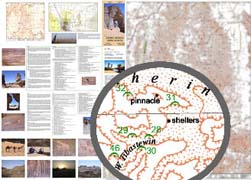
Jebel Acacus, Djebel Akakus Map 1: 100 000 (Libye / Libya)
CHF 34.10 incl. MwSt.
Full colour topographical map covering the Acacus, Tadrart and Awiss mountains
from Serdeles (Al Awainat) to the Algerian border.
Tourist information covering access, the Tuareg, water, archeological sites.
Text in French and English.
This is one of the more fascinating and beautiful areas of Libya. The
mountains of Jebel Acacus cover a vast area of Fezzan east of Ghat. They
contain some of the world’s best examples of cave art, some dating back 12,000
years. The scenes depict hunting, festivities, wild and domesticated animals
and love making.
The main map is a scale of 1:100 000 while on the reverse is a map of the
Northern Acacus at a scale of 1:400 000 – the tourist
guide has information on access the Tuaregs, cave art and walking routes; an
essential piece of kit for anyone thinking of visiting
the Libyan desserts and mountains.
Size: 700×1000, self-cover. 1:100,000, inset 1:400,000
Recommendations on the topic
Hiking / Trekking Guidebooks
Video/ DVD/ Multimedia
Hiking / Trekking Guidebooks
