Israel National Trail – Hike the land of Israel
CHF 56.70 inkl. MwSt.
Fehlt kurzfristig an Lager. Lieferbar in ca. 10 Tagen.
The full guide to the Israel National Trail – Fourth Edition, 2020.
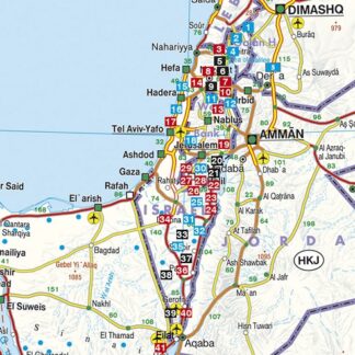
The Israel National Trail [INT] is one of the most exciting hikes in the
world, expanding over 1,100 kilometres from the north to the south of Israel.
You can hike its entire length, or just selected sections of your choice and
you can hike it in winter too. You will experience a great desert hike in the
Negev and Judean deserts and the Dead sea, the lowest point on earth. It is
the ultimate desert hiking experience, and you can do it easily with the guide
that simply has all you need. This full and comprehensive guide includes 62
topographical maps (1:50,000) and 8 road maps (1:250,000). It is an ultralight
guide, that weighs only 300 grams.
The guide offers a full description of the hike in both northbound and
southbound directions together with the hiking profile – distance and height
above or below sea level. You will find in the guide fascinating information
about geology, history, unique botanical information and interesting short
side trips. The maps along with day-by-day trail descriptions and tips make
this guide your one-stop shop and all you need to hike the Israel National
Trail. The guide is suitable for experienced hikers as well as families and
individuals looking to explore Israel in a whole new and exciting way.
The guide has links to important information available as free downloads
including the full preface to the guide, contact information of people in the
desert who will cache water for you, a list of trail angels, list of grocery
stores along the INT, transportation from the airport to the trailhead in Dan
or in Eilat and much more. There is a QR code for trail changes, plus links to
recommended INT alternate routes, and the best day-hikes in Israel. The new
section from Arad to Masada and the Dead sea is included.
| Region | |
|---|---|
| Erscheinungsjahr | |
| Sprache | |
| Autor |
Empfehlungen zum Thema

Wanderführer/ Trekking
Führerliteratur Sportklettern / Bouldern